[App] Locus GIS – land survey, data collection, SHP edit
 Locus GIS : Professional GIS application for working with geodata in the field.
It enables both data collection and viewing. All its features are available over a wide selection of the world’s best online and offline maps.
Fieldwork
collecting and updating field data
saving points with current or arbitrary position
creating lines and polygons by motion recording
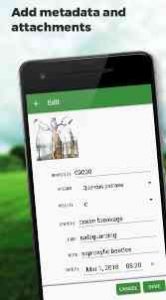
setting related data
photos, video / audio or drawings as attachments
guidance to points
Import / Export
importing and editing ESRI SHP files
exporting data to ESRI SHP or CSV files
exporting whole projects to QGIS
Maps
wide range of online maps
support of WMS map sources
support of offline maps in MBTiles, SQLite, MapsForge, TAR, GEMF, RMAP formats and custom OpenStreetMap data or map themes
Other useful features
measuring distances and areas
searching and filtering of data in attribute table
style editing and text labels
organizing data into layers and projects
Locus GIS user reviews :
- Asamm Software, s. r. o.
- I’m sorry but there wasn’t any built-in feature that would automatically display the property owner. But you probably mean the small label that displays feature name/value of the polygon, line or point in your data layer. If yes, please contact us on help@locusgis.com to discuss it more detailed. Thank you
- Asamm Software, s. r. o.
- Thank you for the review. Please tap on the top button (where is shown ‘LocusGIS’) and choose ‘GPS’. You can display accuracy, num of satellites in the top panel.
- Asamm Software, s. r. o.
- Hi, the map rotation is available i the app. The centering button has two modes – it shifts map on your position and if you tap on it again it enable the map rotation.
- Asamm Software, s. r. o.
- Please contact us at help[at]locusgis.com Attach the project or SHP (if possible) and we’ll check it. Thank you
- Asamm Software, s. r. o
- I’m sorry for complications. It’s still possible to use UTM coordinates. Please open Menu – Projects – settings for project you use – Coordinate reference system – search for UTM and select reference system you require.
- Asamm Software, s. r. o.
- Thanks for the review. I only mention that’s possible to add date/time attribute into layer that automatically filled with current date-time when new item is created. Accuracy and elevation is still missing, thanks for idea.
Really an awesome app for field work and works offline so you can check shape file data on your phone without having have arcgis.
- Asamm Software, s. r. o.
- Thank you, please share your idea at discuss.locusgis.com/
definitely useful app to use the shape his maps out in the field.
- Asamm Software, s. r. o.
- Great :) Thank you
- Asamm Software, s. r. o.
- Hi, would please create new topic at discuss.locusgis.com . Please describe the issue in new topic and please upload the sample problematic SHP file (if possible). We’ll check it. Thanks
- Asamm Software, s. r. o.
- Thank you, we are really glad that you like LocusGIS app
Contact developer :
Download Locus GIS from Play Store
Leave your feedback regarding Locus GIS
You can find our crypto wallets on https://free-apps-android.com/buy-us-a-coffe/
Sponsored Links


