[App] PhotoMap – Geo Photo Gallery

The German Android Magazin (27 April 2015) describes PhotoMap as helpful for holiday, sport and business pictures.
Create impressive geo photo collages and share them with friends. Show your partner, friends, and colleagues where you have been, whether on vacation, at the weekend, on an excursion, on a business trip, or just on a usual day.
NEW:
View photos in your Dropbox.
View photos on network drives or shared Windows directories via CIFS/SMB protocol.
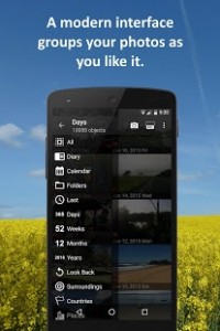
Calendar view
Diary function: Write down all your thoughts, your feelings, and any facts you can think of.
Augmented Reality (AR) view of your photos incl. True North compass
Android 6.0 support (Marshmallow)
The geo logging feature helps you to capture more details about visited places and itineraries. View your logged routes on a map together with your photos.
If your photos don’t have geo positions until now, please activate the “store location” option in your camera app. I recommend using the app MapCam to take pictures with precise geo positions.
PhotoMap enables you to:
Quickly browse even large amounts of photos exactly where you took them.
Enjoy preview pictures situated on a zoomable world map (photo map). Your pictures will be intelligently clustered at their geographical position.
Freely zoom, turn or tilt the 3D world map to enjoy different perspectives.
Freely choose between satellite, street or terrain view.
Easily browse your clustered photos by tapping on the preview pictures.
Create geo photo collages.
Record itineraries, running trails etc. with the integrated geo logger.
Change the location of your photos via drag and drop or add geo coordinates to photos (Geotagging).
Store photo captions in your photos’ metadata. Picasa and other tools on your PC can read it.
Use the built-in camera starter to take pictures with precise geographical coordinates.
View Exif, IPTC, XMP, ICC and other meta data.
Share your photos and geo photo collages via Facebook, Instagram, Twitter etc.
Use PhotoMap if the position and description of photos is important to you. Here are some examples:
When traveling, on vacation, on business trips, when camping, at the beach, in foreign cities, etc.
Make a note of sites such as real estate, homes, cars, hotels, hostels, restaurants, places of work, schools, parking lots, etc.
During sport such as bicycling, rowing, running, jogging, skiing, snowboarding, hiking, trekking, exercising, playing football, etc.
As a spectator at a special event such as a concert, a festival, a football game, a tennis match, etc.
As a visitor to parks, flea markets, zoos, amusement parks, Christmas markets, etc.
On the weekend family outing, at a party/celebration, at a bar/nightclub, in a club, to record the night life etc.
When meeting with friends at the mall, on the playground, while shopping, in a restaurant, etc.
On special occasions such as birthdays, weddings, celebrations, parades, etc.
In the event of a disaster such as an earthquake, storm surge, flood, tsunami, storm, hurricane, forest fire, etc.
PhotoMap is interesting for the following groups: real estate brokers, geologists, inspectors, rangers, craftsmen, firefighters, reporters, police officers, postmen, architects, backpackers, travelers, construction workers, truck drivers, taxi drivers, event managers, stewardesses, guest representatives, actors, facility managers, au pairs, tourism assistants, farmers, foresters, gardeners, insurance agents, soldiers, janitors, pilots, doctors, interior designers, city guides, models, etc.
PhotoMap user reviews :
- March 25, 2016
- Thank you for the comment. I’ve added both points to my to do list.
Good Application You will never forget where your photos are taken
- March 25, 2016
- Thank you for the comment. You probably have seen the ignore option for folders. A hide option could be useful to quickly switch on/off several folders. I’ll think about it
Last Update September 20, 2017 :
Minor improvements
Contact developer :
Video :
Download PhotoMap from PLay Store
Leave your feedback regarding PhotoMap
