[App] Ergfex – hiking & tracking
 The bergfex : hiking & tracking app is a must-have for every hike, ski tour or other outdoor activity.
Find the most beautiful hiking trails in your area or create personal tours with our route planner and track all your outdoor activities. Precise GPS navigation, detailed hiking maps for the entire Alpine region and other useful features bring you safely to your destination.
Get to know the bergfex hiking app for free!
Find hikes or ski tours that suit you
The bergfex tours app contains around 200,000 hiking trails, ski tours, running routes and mountain bike trails throughout Europe. Detailed tour descriptions, topographic hiking maps for the entire Alpine region and filter options make it easy to find the ideal tour.
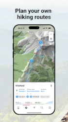
Tour planner and hiking navigation
You haven’t found the perfect hiking or ski tour yet? Then use the bergfex tour planner. In just a few steps you can create your personal hike and let it navigate you to the summit. The precise GPS hiking navigator won’t let you down even in the mountains.
Detailed maps
Our maps for the entire European Alpine region come from OpenStreetMap (OSM). This means that when planning your route and while hiking, you can be sure that you will find the right route thanks to regularly updated maps.
Tracking hiking routes and trails
Track the distance covered while hiking, ski touring, running or mountain biking and get comprehensive statistics such as duration, altitude metres, elevation profile, distance and speed. A heat map shows you all the activities you have recorded so far.
Route and fitness tracking combined
Keep track of your fitness level and activities! Optionally, you can wear a Bluetooth heart rate monitor while hiking, ski touring or other sports to get even more detailed information about your fitness level.
Garmin Connect, websync and GPX-import
Your hikes and planned tours are automatically synchronised with your bergfex account. Tracked activities are also displayed in Garmin Connect and Polar Flow. Self-created routes can be exported and imported via GPX file.
Test many pro functions for 7 days free of charge & without any commitment
Register in the hiking app and test the helpful functions of our PRO subscription on your next hike:
more detailed map material thanks to higher zoom level
warning signal when leaving the route
overlay to visualise slope steepness >30°, 35°, 40°, 45°
official hiking maps such as ÖK50, SwissMap, etc.
offline map material for navigation even without an active internet connection
satellite map with additional information and points of interest
intermediate destinations for route planning
zones for heart rate measurement
hiking, ski touring and more without advertising
Any questions?
If you have any questions or comments about our app, please send us an email at: app[at]bergfex.at
Note: Continuous GPS usage can result in a severe reduction in battery life.
Terms of use: www.bergfex.at/agb
Privacy: www.bergfex.at/datenschutz/
Ergfex user reviews :
Loved it at first but now i paid for pro and tracking doesn’t work properly anymore, regardless if my screen is on or off. I’m really disappointed that the free version almost worked better with it’s limitations Edit: tehy fixed the problem, then it worked well for a month and now I still have problems being tracked when my phone screen is off..
- Hi Clara, danke für Deine Nachricht! Bitte melde Dich mit einer kurzen E-Mail unter app[at]bergfex.at und wir schauen uns das Problem genauer an. Gerne kannst Du uns auch direkt die Log-Files der App mit senden. (Einstellungen -> über bergfex/Touren -> Logs senden (2x antippen)). Viele Grüße, Team bergfex
Theoretically I like the app and it’s features very much. In the past I used the free version and was very happy with it. Now the zoom level is to low if you don’t pay. I paid for the yearly subscription and hoped, some of the bugs would be gone… There are not. Very often the map freezes or the back button just closes the whole app. I hope it doesn’t fail us during a trip on top of a mountain…
- Hallo Benjamin! Wir haben unsere App laufend weiterentwickelt und die von Dir angesprochenen Probleme treten in der aktuellen Version nicht mehr auf. Wir würden uns freuen, wenn Du bergfex nochmals eine Chance gibst und die App testest! Solltest Du Fragen haben, melde Dich jederzeit gerne unter app@bergfex.at. Viele Grüße, Team bergfex
A very good app, with possibility the best maps I’ve encountered so far (clean, crisp, graphically pleasing, with near 3D feel). Altitude data most accurate of all navigation apps I’ve tried. Works great with Garmin, not sure about other brands. The only thing that bothers me is the occasional mix of German and English language, but let’s hope the developers will eventually work out this glitch.
- Hallo Andrej, danke für das äußerst positive Feedback – es freut uns sehr, dass Dir die App so gut gefällt! Bezüglich der unterschiedlichen Sprachen: Kannst Du Dich hierzu vielleicht unter app[at]bergfex.at melden und uns mitteilen, wo genau dieses Problem auftritt? Gerne würden wir uns das näher ansehen. Danke und viele Grüße, Team bergfex
Contact developer :
Download Ergfex from Play Store
Leave your feedback regarding Ergfex
You can find our crypto wallets on https://free-apps-android.com/buy-us-a-coffe/
Sponsored Links


