[App] TrekMe – GPS trekking offline
 TrekMe is an Android app to get live position on a map and other useful information, without ever needing an internet connection (except when creating a map). It’s ideal for trekking, biking, or any outdoor activity.
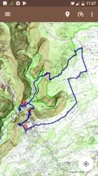
In this application, you create a map by chosing the area you want to download. Then, your map is available for offline usage (the GPS works even without mobile data).
Download from USGS, OpenStreetMap, SwissTopo, IGN (France and Spain)
Other topographic map sources will be added.
Fluid and doesn’t drain the battery
Particular attention was given to efficency, low battery usage, and smooth experience.
SD card compatible
A large map can be quite heavy and may not fit into your internal memory. If you have an SD card, you can use it.
Features
Import, record, and share GPX files
Marker support, with optional comments
Real-time visualization of a GPX record, as well as its statistics (distance, elevation, ..)
Orientation, distance, and speed indicators
Measure a distance along a track
For instance, all map providers are free, except for France IGN – which requires an annual subscription.
If you have an external GPS with bluetooth*, you can connect it to TrekMe and use it instead of the internal GPS of your device. This is especially useful when your activity (aeronautic, professional topography, ..) requires better precision and updating your position at a higher frequency than every second.
(*) Supports NMEA over bluetooth
Privacy
During a GPX recording, the app collects location data even when the app is closed or not in use. However, your location will never be shared with anyone and gpx files are stored locally on your device.
General TrekMe guide
github.com/peterLaurence/TrekMe/blob/master/Readme.md
TrekMe user reviews :
Could you add the option to manually input WGS84 Lat long coordinates, which would then add a marker on the map. Also using OSM to have the option to download the maps for offline usage would be a plus. You see, some people have an old school GPS or a Smartwatch that displays the coordinates in WGS84 format. Being able to have the option to input those coordinates manually to see where they are on the map of your app would be really cool and useful.
- After you placed a marker, you can edit its position and enter specific WGS84 coordinates. Is it working for you? We can discuss that at plr.devs[at]gmail.com
Brilliant for France, limited use in UK. IGN make their maps available free-of-charge and a 40km x 40km square can be downloaded into only 300 MB of storage, and that’s a super-detailed map that will zoom in to a scale of 1:15000 so shows all the farm tracks. Brilliant value at GBP 13.99 for a year. Doesn’t access the OSMaps with footpaths, only the v basic OS maps, so for UK walkers it’s best to stick with the OSMaps app and subscription (GBP23.99 pa)
Just an amazing app, if it’s free maps are enough for you. It let’s you download maps for area, and allows you to specify zoom levels, which can save some 80% of space! (I chose only the closest zoom levels, for example). Custom treks work great, and are fully customizeable, gps is also good. The app itself is super lightweight and responsive.
- Thank you very much!
It is not possible to acquire the extended version once and for all, only to rent it by paying recurring subscription fees ad infinitum. In light of the fact that there are competitor products out there that can be bought instead of rented, this milkingware has been replaced with a functionally superior alternative and is consequently being uninstalled as we speak.
I like the simplicity and the clear system for downloading map tiles. It has access to a fairly detailed level of OS mapping, and track recording works well since the last update.
- Thanks for updating your feedback!
Would like to have an option for scale in miles but otherwise this is a very good compact application. It does what it does very well without a lot of bloated features.
- The new version 2.5.5 has a new option to use the imperial system (miles, yard, ft). What do you think?
OMG, days of searching and uninstalling horrible apps and BAM.. This one comes along and nails it. Offline contours, saved gpx overlays with descriptions. My use is off road trail riding in the mountains. I’m so damn happy . My search is over
- Much appreciated
Great free app for walkers and hikers. Offers just what I need: offline maps and the possibility to import gpx tracks. I don’t need the bloat from paid apps.
Contact developer :
Download TrekMe from Play Store
Leave your feedback regarding TrekMe