[App] ShipAtlas by Maritime Optima
 Download now and get the real-time AIS position of vessels with processed AIS data from more than 700 satellites and terrestrial senders.
ShipAtlas is a FREEMIUM app for everyone interested in AIS vessel tracking and trades, port activities, congestions, sea routes, marine weather, ice conditions, piracy zones and marine maps.
Every second we collect raw AIS data for the global merchant fleet from more than 700 AIS satellites, terrestrial senders, and dynamic AIS sources. We spend time and knowledge in data wrangling, cleaning, and unifying messy and processing complex data sets to give you high quality data.
The vessels are divided into types (segments and sub-segments). Select and deselect vessel segments and sub-segments to get a quick overview of vessels within the segment you are interested in.
Search for vessels by vessel name, IMO or MMSI, or port names and type. Combine searches with more detailed info such as LOA, beam, draft and year built. Search for ports by port name, country or cargo type.
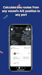
The quick and easy-to-use sea route calculator will give you the ETA, distance in nm, time at sea and estimated bunker consumption. Route from any vessel’s real-time AIS position to any port, or between ports.
Create an unlimited number of vessel lists/fleet lists matching your search criteria and follow the vessels in real-time on the map.
Set notifications on vessels and ports and get updates in real-time.
Turn on your location and find all the vessels nearby you, in a radius of 10 km.
Get the AIS voyage history for all vessels, listed or shown as vessel tracks in the map.
Access daily updated marine information: port activities, tides, local time, congestion, marine weather, ice conditions, and piracy. Add layers on your map: economic zones, Polar Codes, ECA/SECA zones, Load Lines, INL, etc.
Find canals restrictions, view vessels waiting at anchorage, study the activity of the ports, and quickly find real-time bunker prices and availability in more than 5 200 ports.
Use the same login on your mobile as on your laptop/desktop. Your data is automatically synced on all your devices.
A dedicated support chat is integrated in the app and we are happy to assist you at any time.
The data quality, the easy-to-use interface and design, the sea distance calculator (routing from a vessel’s AIS position to any port) and the price makes ShipAtlas one of the best vessel tracking apps there is.
Most features are free but you can upgrade to a paid subscription inside the app and access more features. In-app purchases from €10 per month (on web).
We hope you’ll give ShipAtlas by Maritime Optima a try!
Visit our website to learn more:
maritimeoptima.com/shipatlas
You may also like timestation app
ShipAtlas user reviews :
Excellent app. Very easy to set up and use. I use this app daily for work, this app is vital in my business, scheduling my days off or when I will be working. I can schedule days off in advance. I recommend this app for anyone in shipping or receiving materials . I work 3rd party for Oil & Gas companies (pipe for pipelines) and receive pipe from Italy. So I have to know when and where the Vessels are , when their expected to arrive. Time is Money! 100 % recommend this app! -Joe Lea, Vidor Tx
- Thank you for your glowing review of ShipAtlas! It’s fantastic to know that ShipAtlas is adaptable to various shipping needs, including your role in receiving pipe shipments for Oil & Gas companies. Your endorsement confirms that ShipAtlas caters to a wide range of needs and we are here to support your success in every way we can.
Nice interface, though weather overlay on the map would be nice. Unfortunately, after using it for a day, there is a notification that ship tracks are limited to twenty before $$$$. Bummer.
- We appreciate your feedback! It’s great to know you’re enjoying ShipAtlas’ interface. Your weather overlay suggestion will be taken into account. We understand the frustration with the 20-ship track limit, but upgrading to our paid plans not only supports development of the app but also ensures quality maintenance. Thank you for understanding!
This is one of the most genuine real time ship location app i have used as of now, it shows you the correct location of ship at that time for free, also all the features of the app are accessible for upto 20 searches of ships, 20 searches about port activity and 10 free searches about particular vessel’s voyage history. After you exhaust all the free searches you can only get the real time location of ships on the map and nothing else. The premium is expensive as far as i believe.
- Hi! Thank you for your review, we are glad that you found ShipAtlas reliable and useful. As for upgrading – we offer two plans – Standard & Premium. For more details of please visit our Plan & Pricing page here: maritimeoptima.com/shipatlas/pricing Please reach out to us at post@maritimeoptima.com in case of any additional questions .
Contact developer :
Download ShipAtlas from Play Store
Leave your feedback regarding ShipAtlas
You can find our crypto wallets on https://free-apps-android.com/buy-us-a-coffe/
Sponsored Links


