[App] UTM Geo Map
 UTM Geo Map : Complete, simple, easy to use & free application for Land Surveying, Topography, Bathymetry & GIS. Suitable for Geodesy Engineering, Civil Engineering, Geology and other disciplines related to maps, coordinates, location, address and spatial analysis.
Can be used as a tool in determining position, coordinates, location & address, area & distance measurement, simple spatial analysis such as Overlay, Buffering, TIN / Delaunay Triangulation, Voronoi Diagram, Convex Hull, Smoothing, show WMS Map (Map Server) etc.
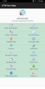
Map Coordinates: Can be used to obtain Latitude Longitude, UTM, MGRS (WGS84) & other CRS (using EPSG codes) in real time, register points complete with coordinate data, time taken, notes/labels, elevation (premium), addresses, photos etc. This module can also display TIN, Voronoi Diagrams and Buffers in realtime from existing points.
Offline GPS: Used to get coordinates in an offline state (without internet access), your cellphone will function like a Handheld GPS to get Latitude Longitude coordinates, UTM, MGRS, Elevation (ellipsoid), MSL Elevation (EGM96), accuracy, satellite and other useful information. Coordinates data can be stored in an unlimited number inside your databases, given notes / labels, photos or exported into CSV, KML, DXF & GPX formats.
Coord. Converter: To convert coordinates manually from Latitude Longitude to UTM & MGRS and vice versa. It can also be used to convert addresses to coordinates (Geocoding, requires an internet connection). Some conversion is support for batch conversion.
Area/Distance: Used to measure distance and area (support units: m, km, ft, miles, hectare, acre), register lines / polygons, make polygons automatically from measure points, create buffers from lines / polygons, overlay etc.. Line / polygon data can be stored in unlimited number inside your database, displayed on a map, added photos and labels or exported to CSV, KML or DXF format. Equipped with spatial editing algorithms such as Snap Nearest, Delete Object Inside / Outside Polygon, Smoothing (cubic bezier interpolation), Split Polygon By Line, and so on. Can read CSV & KML formats to import or display as reference files.
Marker Map: Similar to the Map Coordinates module but with more complete & complex geometry calculation such as displaying Dynamic / Variable Buffers. In this module geometric analysis such as TIN & Voronoi Diagrams can be made from a combination of point data (markers) as well as lines and polygons (breakline). These geometries can also be exported to KML or DXF files for use on other devices or PC.
Compass Map: A module with a map and compass, can be used to assist in navigating or measuring the azimuth angle and determining distance & direction. Equipped with Magnetic Declination data which can be directly corrected to the compass direction.
Overlay: Used to specifically perform overlay operations with several options including Union, Intersection, Difference and SymDifference.
Buffering: Used to specifically perform Buffering operations (creating buffer map) from point, line and polygon data obtained from measurements using other modules.
Elevation Profile: Used to create simple elevation profiles (cross section / long section) from height data with metric & ft / mile units. This module can also create elevation profiles from multiple points including elevation profile from route (premium).
Contours: Module to generate contours based on number of contour lines, desired elevation or contour interval. This is premium modul & need internet connection.
Some other modules: Manage Data, Export File, Buy Premium and Trace KML.
Quick guide (pdf): www.yogantara.info/utmgeomapquickstart.pdf
YouTube: www.youtube.com/channel/UCspxQ5nQiqRD88g_-6GcCqw
Website: www.yogantara.com
Any suggestions are welcome, please submit via email to utmgeomapapp@gmail.com or write a review. Thanks.
UTM Geo Map user reviews :
- Y2 Tech
- Thank you very much for using our APP. There is an import menu in the “Map Coordinate” module that can re-import our exported CSV / KML files that contain point data. If your data is lines/polygon data, it can be re-imported using the import menu in the “Area/Distance” module.
Great app really useful for locating power poles in the back country.
Its good. However it has to give option of editing the notes before saving. It also has to give a better or clearer feedback when a point has been selected.
Contact developer :
Download UTM Geo Map from Play Store
Leave your feedback regarding UTM Geo Map
You can find our crypto wallets on https://free-apps-android.com/buy-us-a-coffe/
Sponsored Links


