[App] MapCam – Geo Camera & Collages
 MapCam : Put an end to imprecise and missing geographical location data (GPS position) in your photos.
Organize your photos before taking them by easily selecting a storage folder. Add photo captions to your images. View your photos and their geo positions on a world map. Create impressive geo photo collages and share them with friends.
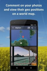
To do all this, MapCam works together with your favorite camera app and stores additional meta data in your photo files. This enables you for instance to view your pictures and photo captions on a world map at the places where you took them (see my apps EagleEye and PhotoMap). In this way, you can go on a trip again by jumping virtually from location to location.
MapCam offers you the following functions:
Easily create and select storage folders for your photos before taking them.
Automatic storage of the best available degrees of latitude/longitude and altitude (in metres above sea level) in the Exif data of your photo files.
Add a descriptive text resp. photo caption to your pictures. The text is saved in the IPTC metadata of your photo file and does not change your photo. Picasa is able to read and show these descriptions on your PC.
Create geo photo collages (map and photos).
Share your photos just after taking them, e.g. via e-Mail, Facebook, Flickr, Google+, Instagram, MMS, Picasa, Skype, Twitter, WhatsApp, Dropbox etc.
Use existing camera apps. Many apps are compatible, e.g. the most preinstalled ones, Camera MX, Cymera, LINE camera, pudding camera, Camera FV-5 Lite, Camera360 Ultimate etc.
Using MapCam is simple:
1. Click the round button as soon as you are happy with the detected position. The button is light green and big when the current position is precise. It is red and small when the position is imprecise.
2. Take your picture: MapCam starts the default camera app or your selected one and stores the best available position in the Exif data of your photo file.
3. Add a descriptive text and share your photo (optional).
Use MapCam if the position and description of photos is important to you. Here are some examples:
When traveling, on vacation, on business trips, when camping, at the beach, at the airport, at the train station, at the museum, etc.
Make a note of sites such as real estate, homes, cars, hotels, hostels, restaurants, places of work, schools, parking lots, etc.
During sport such as bicycling, rowing, running, jogging, skiing, snowboarding, hiking, exercising, playing football, etc.
As a spectator at a special event such as a concert, a festival, a soccer game, a tennis match, etc.
As a visitor to a park, flea markets, zoos, amusement parks, Christmas markets, etc.
On the weekend family outing, at a party/celebration, at a bar/nightclub, in a club, to record the night life etc.
When meeting with friends at the mall, on the playground, while shopping, in a restaurant, etc.
On special occasions such as birthdays, weddings, celebrations, parades, etc.
In the event of a disaster such as an earthquake, storm surge, flood, tsunami, storm, hurricane, forest fire, etc.
MapCam is interesting for the following occupational groups: real estate brokers, dealers, craftsmen, firefighters, police officers, construction workers, drivers (truck drivers, taxi drivers), event managers, foresters, gardeners, janitors, pilots, soldiers, etc.
MapCam user reviews :
This is a fast and simple app. The encoded GPS data is represented on the adjacent map in lightening fast speed. It is extremely helpful to catalog photos without try to retrace steps. No matter what order photos are taken in, getting them organized is a snap. The debate of; “I think it was over there instead,” has been settled!
Good and working app
- Dr. Ludger BischofsDecember 25, 2016
- MapCam doesn’t run on startup! Location updates are deactivated automatically when MapCam isn’t used anymore. Have you been paid to write a bad review?
- Dr. Ludger BischofsDecember 18, 2016
- Thank you.
The app is so useful to me in my documentation as it facilitates collage of a subject e.g. a building with location in map. But it doesn’t not work without internet. Instead 3 d camera compass works without net, with GPS only and produces nearly 550 kb images. In map cam collageed images are nearly 100 kb only. So pl solve these two bugs. THNX in advance. 4 star for present and 1 star reserved to be awarded after the bugs are fixed.
- Dr. Ludger BischofsApril 8, 2016
- An internet connection is needed to show the map. Is the blank screen blue or black? If it’s blue then the photo may not have a gps position. What camera app are you using? Please make sure that the latest version of the Google Play Services are installed. Thanks.
Contact developer :
Download MapCam from Play Store
Leave your feedback regarding MapCam
You can find our crypto wallets on https://free-apps-android.com/buy-us-a-coffe/
Sponsored Links


